![](/images/other/stat-length.png)
![Randonnée Course à pied La Ville-aux-Clercs - Sur les Traces du Loup - La Ville aux Clercs - Photo](https://media.geolcdn.com/t/1900/400/ext.pjpeg?maxdim=2&url=https%3A%2F%2Fservices.sitytrail.com%2FGeolivesWS%2FDownloadMedia.ashx%3FTrailID%3D317966%26Media%3D17408_3.jpg)
Sur les Traces du Loup - La Ville aux Clercs
tracegps
Utilisateur
![Longueur](/images/other/stat-length.png)
Longueur
31 km
![Altitude max](https://static1.geolcdn.com/siteimages/upload/files/1508320355ic_sort_altitude_max_24dp.png)
Altitude max
186 m
![Dénivelé positif](https://static1.geolcdn.com/siteimages/upload/files/1508320355ic_sort_den_pos_24dp.png)
Dénivelé positif
376 m
![Km-Effort](/images/other/stat-length.png)
Km-Effort
37 km
![Altitude min](https://static1.geolcdn.com/siteimages/upload/files/1508320355ic_sort_altitude_min_24dp.png)
Altitude min
110 m
![Dénivelé négatif](https://static1.geolcdn.com/siteimages/upload/files/1508320355ic_sort_den_neg_24dp.png)
Dénivelé négatif
376 m
![Boucle](https://static1.geolcdn.com/siteimages/upload/files/16400158638029165_repeat_loop_refresh_sync_direction_icon.png)
Boucle
Oui
Date de création :
2014-12-10 00:00:00.0
Dernière modification :
2014-12-10 00:00:00.0
![Course à pied](https://static1.geolcdn.com/sitytour/trail-icons/103.png)
3h30
Difficulté : Difficile
![Scannez ce code QR pour ouvrir la randonnée dans l'application SityTrail](https://capi.geolives.com/qq0zvz2zws4bq2lad0pu/sitytour/trails/317966/qr.png?size=200)
Application GPS de randonnée GRATUITE
À propos
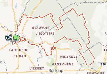
Randonnée Course à pied de 31 km à découvrir à Centre-Val de Loire, Loir-et-Cher, La Ville-aux-Clercs. Cette randonnée est proposée par tracegps.
Description
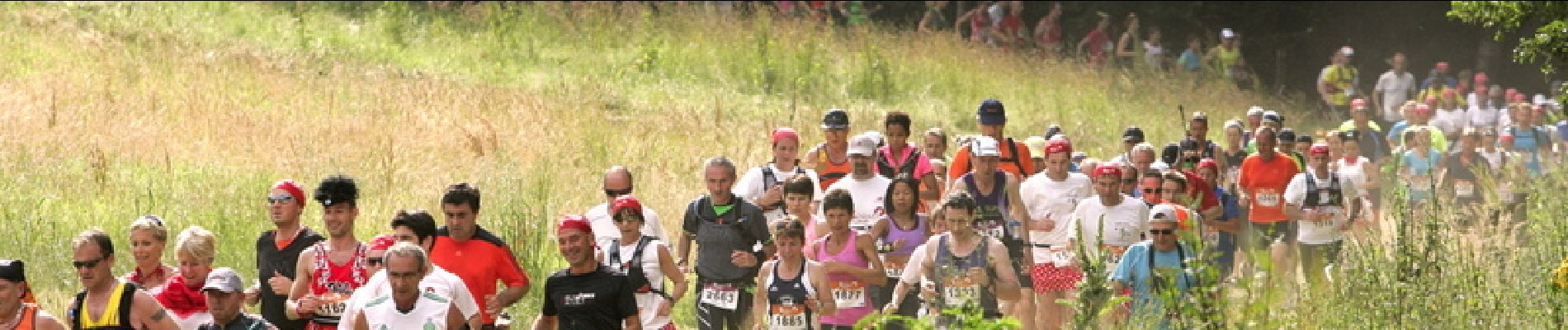
Le parcours de 33km Sur les Traces du Loup. Le dénivelé avoisine les 300 m, passage de gués, lit de rivière, traces en forêts, lisières, chemins calcaires, champs, fossés… Crédit photos www.lepape-info.com
Localisation
Pays :
France
Région :
Centre-Val de Loire
Département/Province :
Loir-et-Cher
Commune :
La Ville-aux-Clercs
Localité :
Unknown
Départ:(Dec)
Départ:(UTM)
356609 ; 5308574 (31T) N.
Commentaires
Randonnées à proximité
![Randonnée Marche Rahart - Rahart - Photo](https://media.geolcdn.com/t/375/260/f650ba70-4d58-496b-8e3a-7549b98be635.jpg&format=jpg&maxdim=2)
![Marche Marche](https://static1.geolcdn.com/sitytour/trail-icons/101.png)
Rahart
Marche
Facile
Rahart,
Centre-Val de Loire,
Loir-et-Cher,
France
![](/images/other/stat-length.png)
8,1 km | 9,3 km-effort
2h 6min
![](https://static1.geolcdn.com/siteimages/upload/files/16400158638029165_repeat_loop_refresh_sync_direction_icon.png)
Oui
![Randonnée Marche Busloup - Busloup - Photo](https://media.geolcdn.com/t/375/260/ext.jpg?maxdim=2&url=https%3A%2F%2Fstatic1.geolcdn.com%2Fsiteimages%2Fupload%2Ffiles%2F1553511878bg_sport_marche.png)
![Marche Marche](https://static1.geolcdn.com/sitytour/trail-icons/101.png)
Busloup
Marche
Facile
Busloup,
Centre-Val de Loire,
Loir-et-Cher,
France
![](/images/other/stat-length.png)
21 km | 25 km-effort
3h 8min
![](https://static1.geolcdn.com/siteimages/upload/files/16400158638029165_repeat_loop_refresh_sync_direction_icon.png)
Oui
![Randonnée Marche La Ville-aux-Clercs - ville aux clercs - Photo](https://media.geolcdn.com/t/375/260/ext.jpg?maxdim=2&url=https%3A%2F%2Fstatic1.geolcdn.com%2Fsiteimages%2Fupload%2Ffiles%2F1553511878bg_sport_marche.png)
![Marche Marche](https://static1.geolcdn.com/sitytour/trail-icons/101.png)
ville aux clercs
Marche
Facile
La Ville-aux-Clercs,
Centre-Val de Loire,
Loir-et-Cher,
France
![](/images/other/stat-length.png)
8,3 km | 9,3 km-effort
2h 29min
![](https://static1.geolcdn.com/siteimages/upload/files/16400158638029165_repeat_loop_refresh_sync_direction_icon.png)
Non
![Randonnée Marche Busloup - essai - Photo](https://media.geolcdn.com/t/375/260/ext.jpg?maxdim=2&url=https%3A%2F%2Fstatic1.geolcdn.com%2Fsiteimages%2Fupload%2Ffiles%2F1553511878bg_sport_marche.png)
![Marche Marche](https://static1.geolcdn.com/sitytour/trail-icons/101.png)
essai
Marche
Très facile
Busloup,
Centre-Val de Loire,
Loir-et-Cher,
France
![](/images/other/stat-length.png)
7,9 km | 9 km-effort
1h 58min
![](https://static1.geolcdn.com/siteimages/upload/files/16400158638029165_repeat_loop_refresh_sync_direction_icon.png)
Oui
![Randonnée Marche Busloup - essai - Photo](https://media.geolcdn.com/t/375/260/ext.jpg?maxdim=2&url=https%3A%2F%2Fstatic1.geolcdn.com%2Fsiteimages%2Fupload%2Ffiles%2F1553511878bg_sport_marche.png)
![Marche Marche](https://static1.geolcdn.com/sitytour/trail-icons/101.png)
essai
Marche
Très facile
(1)
Busloup,
Centre-Val de Loire,
Loir-et-Cher,
France
![](/images/other/stat-length.png)
7,9 km | 9 km-effort
1h 58min
![](https://static1.geolcdn.com/siteimages/upload/files/16400158638029165_repeat_loop_refresh_sync_direction_icon.png)
Oui
![Randonnée Marche Busloup - 29 decembre La ville aux clercs - Photo](https://media.geolcdn.com/t/375/260/ext.jpg?maxdim=2&url=https%3A%2F%2Fstatic1.geolcdn.com%2Fsiteimages%2Fupload%2Ffiles%2F1553511878bg_sport_marche.png)
![Marche Marche](https://static1.geolcdn.com/sitytour/trail-icons/101.png)
29 decembre La ville aux clercs
Marche
Très facile
Busloup,
Centre-Val de Loire,
Loir-et-Cher,
France
![](/images/other/stat-length.png)
7,9 km | 9 km-effort
1h 58min
![](https://static1.geolcdn.com/siteimages/upload/files/16400158638029165_repeat_loop_refresh_sync_direction_icon.png)
Oui
![Randonnée Marche Busloup - La ville aux clercs - Photo](https://media.geolcdn.com/t/375/260/ext.jpg?maxdim=2&url=https%3A%2F%2Fstatic1.geolcdn.com%2Fsiteimages%2Fupload%2Ffiles%2F1553511878bg_sport_marche.png)
![Marche Marche](https://static1.geolcdn.com/sitytour/trail-icons/101.png)
La ville aux clercs
Marche
Très facile
Busloup,
Centre-Val de Loire,
Loir-et-Cher,
France
![](/images/other/stat-length.png)
7,9 km | 9 km-effort
1h 58min
![](https://static1.geolcdn.com/siteimages/upload/files/16400158638029165_repeat_loop_refresh_sync_direction_icon.png)
Oui